‘Because we just don’t know’: Preparing for tropical storm force winds, heavy rain, ocean surge

")


Thursday afternoon, the harbors in the Midcoast were getting cleared of dinghies and sailboats, in anticipation of rolling oceans and heavy winds. The path of Hurricane Lee shifted again slightly eastward, after shifting westward Wednesday, and sending harbor masters into high gear.
The theme of Hurricane Lee, since it started making a beeline for the Maine and Canadian Maritime coastline, was, ‘We don’t know what it will do, what the effects might be, but we’re preparing for the worst.’
After experiencing several years of heavy, damaging storms, local communities are taking no chances. And with the harbors still chock full of recreational vessels, floats and docks, the concern over property damage runs high.
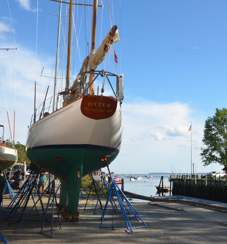
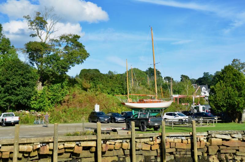
At Rockport Harbor late in the day Sept. 14, the skies were clear, and the temperatures balmy – perfect weather to go out on the water. But the sentiments ran the other way, with boat haulers busy all week lifting and transporting boats to yards or homes, or the east side of the harbor for temporary storage.
Rockport Marine’s expert boat hauler Walter Gray had spent much of the day moving sailboats, their rigging intact, a short distance from the Travelift to a temporary boat storage location on the northeast side of the harbor. He carefully backed them into place, onto stands, giving them safety from the heavier storm conditions. It was a rare glimpse of the beautiful hulls and keels in one place.
The latest forecast on Hurricane Lee for the immediate Midcoast falls under a Tropical Storm Warning. This means hazardous weather from Friday through late Saturday afternoon, with high surf, and a peak storm surge of 1 to 3 feet. Winds are expected to be between 30 to 40 mph with gusts to 60 mph.
The following applies to Knox, Waldo, Lincoln counties, issued at 6 p.m., Thursday, Sept. 14.Hurricane Lee will continue to move north while expanding in size. The northward movement will continue through the end of the week, bringing it into the Gulf of Maine late Friday night or early Saturday morning.
As the storm moves north, it is expected to slowly weaken, but the wind field will continue to expand significantly. Therefore, tropical storm conditions are expected along the coast and may develop as early as Friday evening, with the threat continuing through Saturday evening.
The strongest winds are expected across coastal portions of New Hampshire and Maine. Large, pounding surf in addition to one to three feet of storm surge will result in beach erosion and minor to pockets of moderate coastal flooding.
Heavy rainfall is also possible, particularly across Midcoast Maine where localized flooding will be possible.
There remains some uncertainty with regards to the exact track of Lee, which will play a role in the level of impacts experienced across the area, but confidence is higher for locations further east.
WIND: Prepare for dangerous wind having possible significant impacts across coastal New Hampshire and western Maine. Potential impacts in this area include: - Some damage to roofing and siding materials, along with damage to porches, awnings, carports, and sheds. Mobile homes may be damaged, especially if unanchored.
Unsecured lightweight objects become dangerous projectiles. - Numerous large trees snapped or uprooted, leading to downed power lines. - Many roads are impassable from debris, caused by downed trees and power lines.
Many bridges, causeways, and access routes impassable. - Numerous power and communications outages likely. Also, prepare for hazardous wind having possible limited impacts across coastal New Hampshire and western Maine. *
FLOODING RAIN: Protect against locally hazardous rainfall flooding having possible limited impacts. Potential impacts include: - Rivers and tributaries may quickly rise with swifter currents. Small streams, creeks, canals, and ditches may become swollen and overflow in spots. - Flood possible in a few places where rapid ponding of water occurs at underpasses, low-lying spots, and poor drainage areas. Several storm drains and retention ponds become near-full and begin to overflow. Some brief road and bridge closures. - Backed up drainage systems near the coast could exacerbate the flooding from rainfall.
Prepare for locally hazardous rainfall flooding having possible limited impacts across western Maine.
SURGE: Prepare for locally hazardous surge having possible limited impacts across coastal New Hampshire and western Maine. Potential impacts in this area include: - Localized inundation of up to 1 foot mainly along low-lying spots on the immediate shorelines and in tidal affected riverine areas farther inland. Storm surge flooding could be accentuated by large waves in vulnerable wave action shoreline locations. - Sections of near-shore roads, causeways, and parking lots become overspread with surge water. Dangerous driving conditions in places where surge water covers the road. - Minor to moderate beach erosion.
Heavy surf also breaching dunes, mainly in usually vulnerable locations. Strong rip currents. - Minor damage to marinas, docks, boardwalks, and piers. A few small craft broken away from moorings.